| |
|
  Navigation during Viking age |
|
|
| |
|
|
Navigation during Viking age |
|
|
![]() Hem
Hem
- The world in the viking world
- To draw a viking age map
- The basics of navigating
The instruments:
- The sun stone, -
The sun compass, - The sun shadow disc, -
The logg and the lead
- To navigate
- Conclution
|
The Vikings could navigate! That is a fact. They were able to select course, bearing and position. Navigating on the same manner as navigation has always been done before the GPS entry 20 years ago. How else could they navigate hin and forth across the atlantic?
This article is about viking navigation methods. Except for the few fragments of navigation equipments found there is not much that tells us about their methods. Books from the medieval are a good source to were they sailed but not good enouth on how they did navigate. Modern practical archaeology has reveeled some of the secrets. How did the vikings experience the map of their world? They had naturally only their aquired experience during life to go back on. They were not able to draw their maps on our modern ways (using of aerial photographs, GPS etc).They were also not using modern triangular surveying methods . Their maps were drawn using only experience. I will call them "Experience Based Maps". If we use a ruler to measure their maps, will we find so big faults in them that we willl dispatch them as unusable. But are they really wrong? The truth is maybe that we can't utilize them with our modern way of thinking.
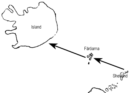
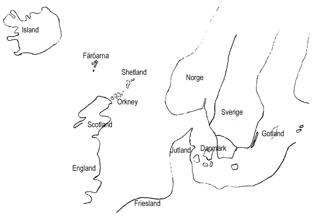
I am going to make an intellectual experiment to explain the way of thinking and how the vikings experienced their world surroundings. Think for yourself that you have'nt seen a modern map or an aereal photograph, that you do'nt know how the world looks from the air or from space. Your knowledge comes only from your own experiences and from what others have told you. You have sailed a good deal both along the Scandinavian coast and out on the Atlantic. To your help with navigation you have used local pilots who knows his coastal surroundings. We shall now draw a map on paper. The Scandinavians did'nt draw maps on paper until the middle of the medieval but this simplifies for ourselves to understand the experiment. I will draw an experience based map over the north Atlantic. You know that if you sail from Bergen in Norway is it normaly four days of sailing, by normal speed, direct west to reach Shetland. You also know that you should sail course due SE x E (South East by East) from Shetland and sail into Skagerrak within five to six days. We draw it on the map.. 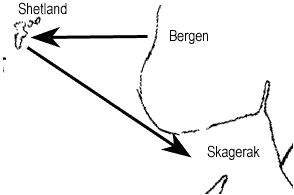
To reach Faeroe islands you sail from the Shetlands 3 to 4 days further with NW x W course. Same course is it to Iceland..
Knowledge of distances (time distances) and some knowledge of how the islands looks like will enable us to draw a map over North Eastern Atlantic. An "Experience Based Map". An experienced skipper of course keep the map in his mind, not on paper. He knows how to sail to particular place.
To navigate you require knowledge of the world around and navigation instruments. The instruments will help us evaluate the surroundings. The instruments probably used by the vikings were for instance the Suncompass, the Sunshadow disc, the Sunstone , the Log and the Lead and moreover - the Ship itself. The knowledge of the world around are based on observations (like the weather and wind & sea conditions , speed, birds, shapes of land water caracter) and experiences (olds journeys , maps, descriptions, pilot knowledges) All these instrument and observations is needed to navigate. It is only the last 10 yearsr with the using of the GPS that we have forgotten to use most observations. Todays instruments are more precise and not as depending on good weather conditions. I will explain the instruments down beneath. But without observations would the instruments not reach far in navigating. You have to observe weather and wind, Changes, courses and new weather fenomenas. It is exceedingly important to document the observations during course. Today we are using paper and pen but you can of course store it in your mind. What about the waves? The sea and waves effects the drift and you can see the wind and the speed in the waves. Birds, animals and water caracter tells you about land and distances. It is all about lerning to read and understand the observations.
We start with the sunstone, this mythical stone. The thought is to use the stone to understand the course to the sun. I have never seen any good sunstone. The sun should be projected into the stone and show the suns direction by polarisation then ist cloudy. Rumours have it that an exceedingly precise sunstone have been found at Öland or Gotland in Sweden.
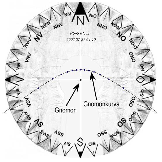
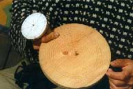
A Compass. More precise than a magnet compass due to no magnet deviating problems. But the sun compass is losing in accuracy time and and must be recorrected after a few weeks. The compass is a round disc about 72 mm in diameter with a pendula foot underneath for stabilating the compass horizontally. A peg in middle of the disc, the so called "gnomon". On the disc is also a Gnomon-graph drawed. The graph markes the curve that the shadow from the peg points to during the day. The shape of the graph depends of the season, latitude and pegs hight. The north line intersects the curve at the graph shortest distance from the gnomon-peg. The compass card is devided in 32 directions. The compass is also able to use as a ruff clock. The compass have in practical tests showed to be most precise with a disc of about 70-75 mm diameter , not in a diameter of 125 mm, as many archaeologists maintain. Deviating were probably made the last day (or maybe a few days) before the departure. To deviate you have to sit down with the disc in the sun and point out the gnomon sillhouette point approximately once an hour from morning till evening. Then you have to connect the dots to a graph.
Instrument for measuring the celestial sight. A disc with a peg in centre and marked circles in regular intervals. A precursor to the sextant. Rightly used it will give less than a few percent poorer accuracy. The disc is used to measure how far north you are. The best way to do the mesureing is that one person holds the disc horizontally in eye hight (90 degrees away from the sun). Annother person makes the reading. This procedure is tested to be the best way to make the accuracy better because it takes away the interference from the waves in a good way Thereby is the disc very precise.
For example a floating rope with knots on levels for ship speed measuring.
A rope with markings on levels for depth measuring. In the end of the rope is a fastned weight.
It is altogether possible to navigate and find the way with viking age methodes. During the journeys where i have participated have of course been of different successes. Some incredebly accurate and others not very good. Reasones to fail is that we sail to seldom, that we tend to not accept our instincts and of corse that the weather fools us and gives us bad conditions for a long time. It is also difficult to understand the affect of the different currents. If you have your documentation in order and you atleast see the sun once a day (if you do'nt have a good sun stone) then you can with good accuracy navigate. More thän 15 degrees of navigation fault is unneccecary to get, not even at the bad conditions (thunder, gusty wind, cloudy or maybe mist or changing currents). I think that you normally should be able to, with good margin, in open sea keep within 5 degrees of your course. 15 degrees fault sounds as a lot, but you easily with good margin reach Shetland, Faeroe islands, Iceland, Grenland and even America. All journeys to Viking destinations could easily been done.
To imagine and to understand the viking world is maybe not so easy. We have difficulty to think back into a time when they did'nt know the modern science. Today we know the looks or the world from photographs, so we tend to look with scepticism on the medieval maps and their natural faults. But if we did'nt have that knowledge and used them in the manner they were intended to be used, should the medieaval maps look perfectly natural. That is the way we must think to understand the viking world for full. It has been a fantastic adventure to experiment with the viking age instruments and trying to understand the navigation methods. I am far from fully skilled. This article shares some of my experiences in viking navigation. Many of the experiments have been done on vikingships, together with SVS (the Society of Viking age Ships).
I would finaly thank Lena Börjesson (Fosen Folkhögskola), for helping me experimenting and lerning about the viking age navigation. I will also give my thanks to the friends on the viking ship Vidfamne for all fantastic moments aboard. I will keep this inspiration with me for the future. © 2004 Ove Långe |
![]()
![]()
![]()
![]()
![]()
![]()
![]()
![]()
![]()
![]()
![]()
![]()
![]()
![]()
![]()
![]()
![]()
![]()
![]()
![]()
[ ©
Ove Långe Vikingship site ]
© 2004 Ove Långe
info@vikingship.se